Attraction เกาะหมาก Maak Island : ตราด
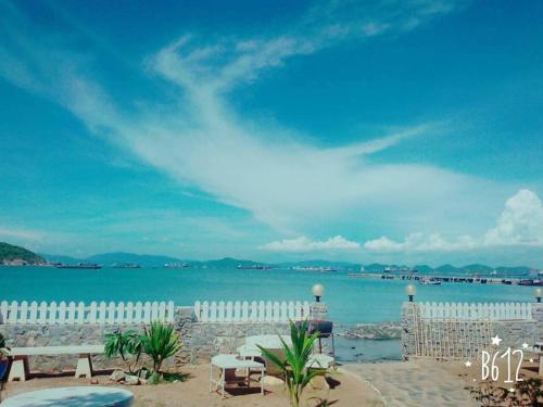
เกาะหมาก ตั้งอยู่ที่ ตำบลเกาะหมาก กิ่งอำเภอเกาะกูด มีอยู่เพียง 2 หมู่บ้านคือ หมู่ 1 บ้านอ่าวนิ และหมู่ 2 บ้านแหลมสน มีประชากร ประมาณ 350 คน สภาพพื้นที่เกาะหมากเป็นที่ราบชายฝั่งและภูเขาสูงบางส่วน มีรูปร่างคล้ายดาวสี่แฉก ประชากรส่วนใหญ่ประกอบ อาชีพเกษตรกรรม ทำสวนมะพร้าว สวนยางพารา โดยรอบเกาะหมากจะมีหาดทรายขาวสะอาด โดยเฉพาะบริเวณที่เป็นอ่าว 3-4 อ่าว คือ อ่าวสวนใหญ่ อ่าวพระ อ่าวขาว อ่าวนิด และที่หมู่เกาะใกล้ๆมี แหล่ง ปะการังที่สวยงามดังนั้น เกาะหมากจึงเป็นแหล่งท่องเที่ยว ทางธรรมชาติที่สวยงามอีก แห่งหนึ่งของ หมู่เกาะในจังหวัดตราด ซึ่งใน2-3 ปีที่ผ่านมาเกาะหมากได้รับความนิยมจากนักท่องเที่ยว เพื่อมาพักผ่อน น้ำทะเลใส ที่สามารถลงเล่นน้ำได้ มีวิถีชาวบ้านอันสงบ เรียบง่าย ซึ่งยังคงดำรง ชีพด้วยการทำเกษตรกรรม เช่น ทำสวนยางพารา ประมงพื้นบ้าน อีกทั้งบริเวณชายฝั่งรอบเกาะ และเกาะใกล้เคียงยังมีแนวปะการังที่สมบูรณ์

เกาะหมาก Maak Island
![]()
เกาะหมาก เป็นเกาะขนาดใหญ่ มีรูปร่างคล้ายดาวสี่แฉก อยู่ระหว่างเกาะช้างกับเกาะกูด ห่างจากฝั่งประมาณ 38 กิโลเมตร มีพื้นที่ทั้งหมดประมาณ 9,000 ไร่ มีรูปร่างคล้ายดาวสี่แฉก พื้นที่ส่วนใหญ่เป็นที่ราบสวนมะพร้าว โดยรอบมีอ่าว ชายหาดที่สวยงาม และน้ำใสสะอาดหลายแห่ง เช่น บริเวณอ่าวตานิด อ่าวไผ่ อ่าวโปร่ง อ่าวผาด อ่าวแดง อ่าวส่วนใหญ่ บริเวณชายฝั่งรอบเกาะและเกาะใกล้เคียงพบแนวปะการังที่สมบูรณ์ และสวยงาม บนเกาะมีที่พักสำหรับนักท่องเที่ยวด้วย ชุมชนดั้งเดิมบนเกาะหมากส่วนใหญ่เป็นเขมรเชื้อชาติไทยที่อพยพเข้ามาตั้งถิ่นฐานเมื่อครั้งเมืองประจันตคีรีเขตร หรือเกาะกงเป็นของฝรั่งเศสเมื่อปี พ.ศ. 2447 โดยมีหลวงพรหมภักดี ต้นตระกูลตะเวทิกุล เป็นผู้ควบคุมคนจีนบนเกาะกง คนบนเกาะส่วนใหญ่เป็นเครือญาติกัน มีอาชีพเกษตรกรรมทำสวนยางพารา และสวนมะพร้าว จนเกาะหมากได้ชื่อว่าเป็นแหล่งปลูกมะพร้าวที่สำคัญของจังหวัดตราด
![]()
![]()
Koh Mak is located at Tambon Ko Mak, Ko Kood Sub-district. There are only 2 villages which are Moo 1 Ban Ao Nid and Village 2 Ban Laem Son, with a population of about 350 people. Koh Mak is a coastal plain and some high mountains. It is shaped like a four-pointed star. The majority of the population comprises agriculture occupation; coconut plantation and rubber plantation. Around Koh Mak, there will be clean white sand beaches; especially in the area of 3-4 bays, which are Ao Suan Yai, Ao Phra Ao, Ao Khao, Ao Nid. And, the nearby islands, there are beautiful coral sources. Therefore, Koh Mak is another beautiful tourist attraction among the islands in Trat Province. As of which, in the past few years, Koh Mak has been popular who tourists who come to relax. The water is clear and you can swim. There is a peaceful and simple village life, which still makes a living through agriculture such as rubber plantation and local fisheries. In addition, the coastal areas around the island and nearby islands also have complete coral reefs.
![]()
Koh Mak is a large island that is shaped like a four-pointed star, located between Koh Chang and Koh Kood. It is approximately 38 kilometers from the shore with a total area of approximately 9,000 rai and most of the area is plains of coconut plantations. It is surrounded by beautiful beaches and bays such as Ao Tanid, Ao Phai, Ao Prong, Ao Phat, and Ao Daeng. Perfect and beautiful coral reefs are found in most of the bays and the coastal areas around the island and nearby islands. The island has accommodation for tourists as well. The indigenous communities on Koh Mak are mostly Khmer of Thai ethnicity who migrated to settle in Prachantakhiri Khet. Or Koh Kong belonged to France in the year 2447 with Luang Phrom Phakdi the ancestor Tavetikun family who controlled the Chinese on Kong Island. Most of the people on the island are related and make a living in agriculture, rubber plantations and coconut groves to the extent that Koh Mak is known as the major coconut plantation area of Trat Province.
![]()
![]()
![]()
![]()
![]()
Latitude : 11.818967961775478, Longitude : 102.47892834431008
View Larger Map

View On Google Map
Edit Data
Images
-
เกาะหมาก Maak Island
-

เกาะหมาก Maak Island
-

เกาะหมาก Maak Island
-

เกาะหมาก Maak Island
-

เกาะหมาก Maak Island
-

เกาะหมาก Maak Island